Double Eagle II Airport
I’ve added 15.5 hours to my logbook in the last 30 days, 7.7 of them on my most-complex trip yet.
It didn’t take long for me to realize flying in Denver will be different than California. The places worth going are far; it’s 350nm minimum to a meaningful city (Wichita, Oklahoma City, Albuquerque) and still 300nm to the little places worth going like national parks and monuments. Add the unpredictable weather (my first attempt at KAEG failed when forecast 20kt winds were 45kt), afternoon thunderstorms, and universally high density altitudes, and it’s a recipe for some complex flight planning.
Note the daily thunderstorms!
That made this weekend overnight to KAEG this 200-or-so-hour pilot’s most challenging flight by quite a margin!
- Longest-ever leg – 450nm vs. 180nm. (Longest non-dual only 140nm.)
- First non-dual flight over mountainous-ish terrain. (Terrain >8000 ft, near peaks >9500 ft. Yes, in Denver, this is only mountainous-ish.)
- Second-ever overnight flight.
- Second-ever refueling on the road and the first time needing a fuel stop en route.
- Second-highest DA takeoff. (8400 ft.)
If some of those numbers sound insane, you must not fly in Colorado. My club in California calls it “mountains” anytime the DA is >3000 ft. Ha! Anyway, let’s talk the route (roughly) and how it went.
- KBJC
- VPCRZ
- BRK - Avoid the charlie. Fly 9500.
- PUB - Avoid the warning area.
- 4V1 - Follow I-25.
- KRTN - Avoid Fishers Peak at 9600’. Begin climb 20nm early. Land to refuel.
- FTI
- TAFOY
- SAF - Cut the corner over lowest terrain.
- KAEG - Avoid the charlie.
The weather concerns on the trip south were, of course, afternoon thunderstorms. Otherwise the winds were forecast to be several knots headwind.
The departure from KBJC was fine – straight out until exiting the delta then south skirting the hills until flying under just the SW corner of the bravo’s 10k MSL shelf. Turns out nobody uses the charted flyways east of KBJC – they just go west of it instead. The foothills are prettier that way anyway.
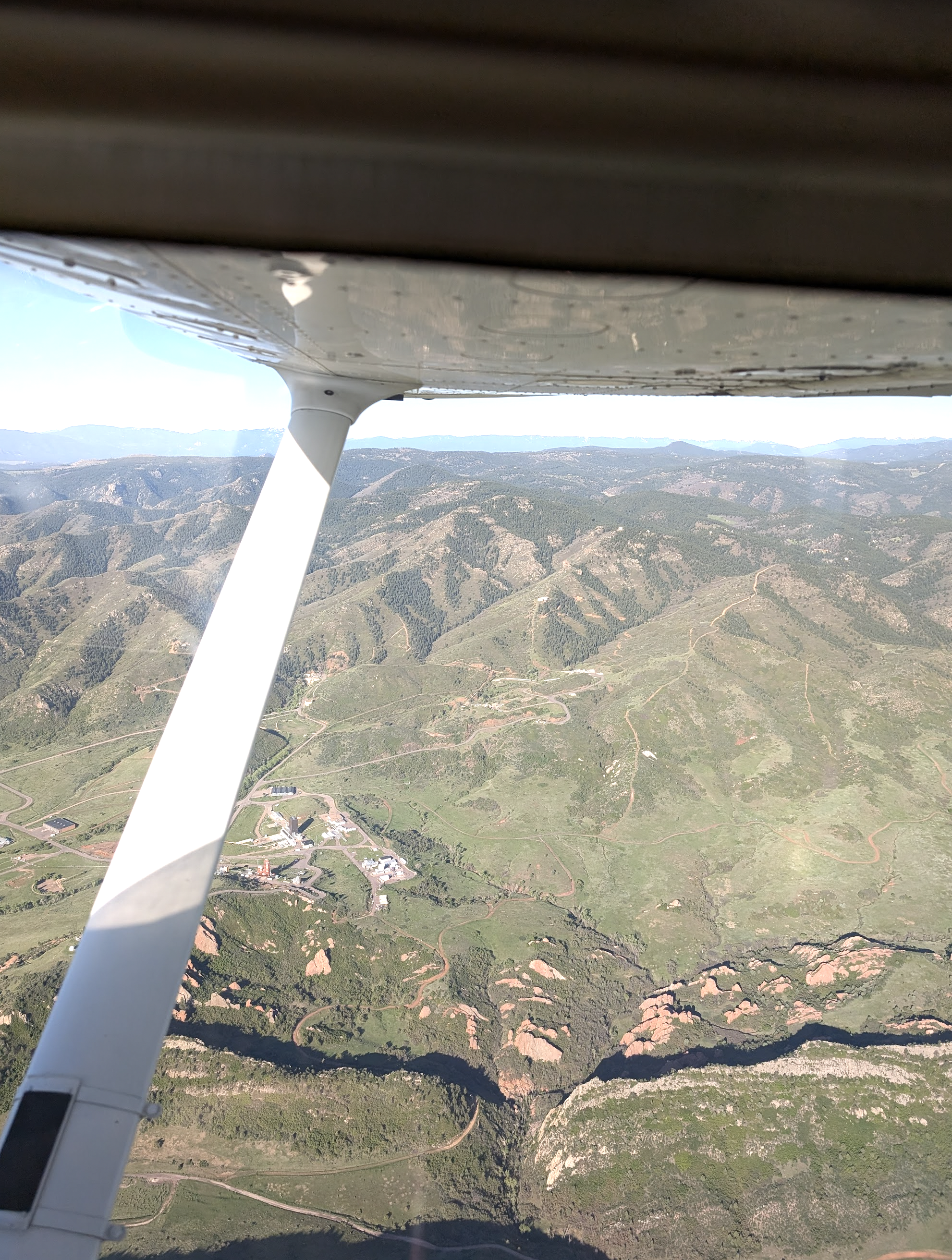
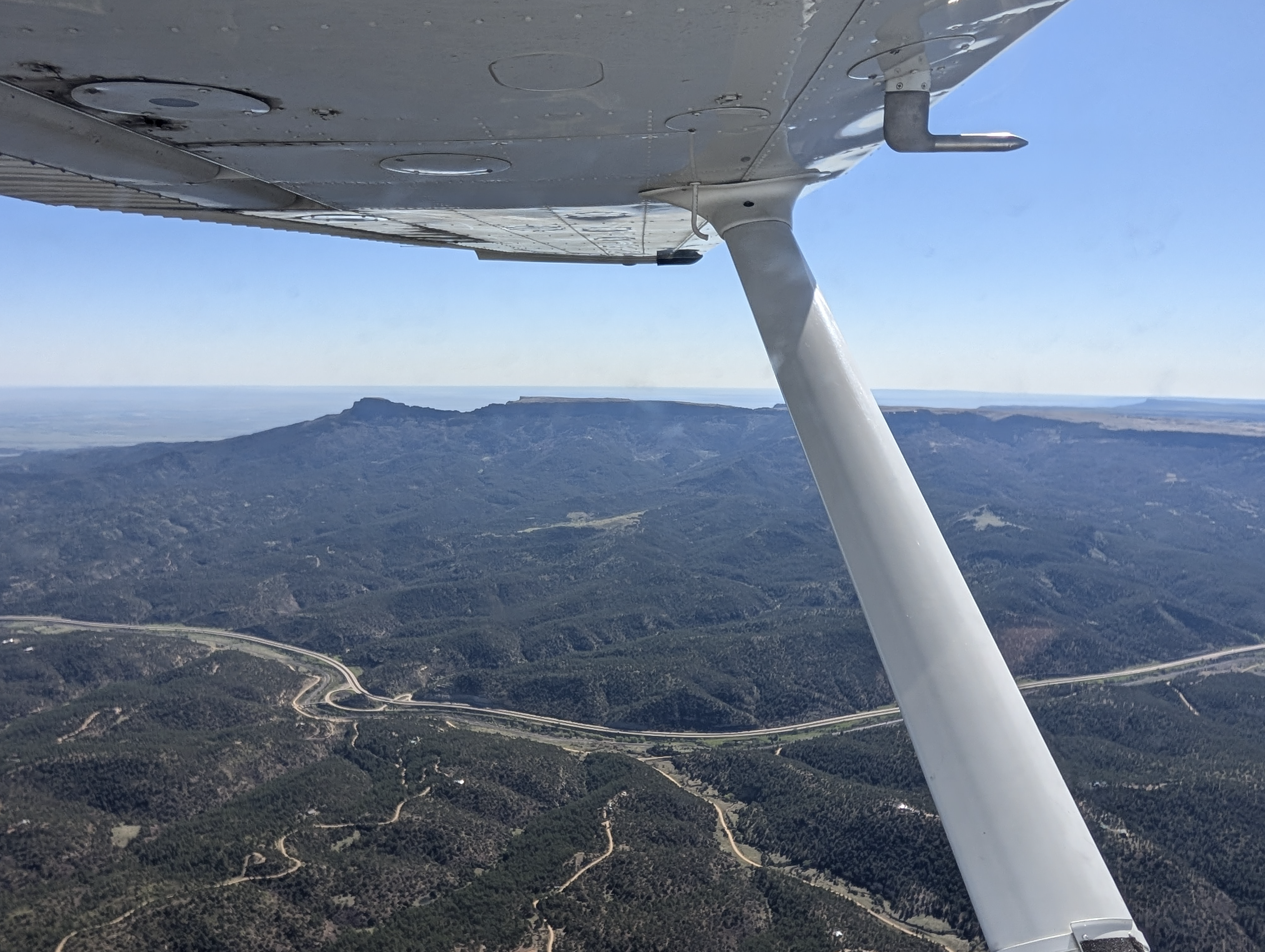
We originally got flight following to KPUB expecting to land there to refuel and rearm1 – I mean reset. But after a quick in-flight sandwich we felt good enough to press on, which was fine by me. I’d rather have less gas for that 9am leg over the highest terrain of the flight, Raton Pass. Just a couple miles from our leg is Fishers Peak at 9620’, and the crosswind wanted to push us right into it. Going around it would’ve added 100nm to our trip.
I wasn’t the only one worried; when I got switch to Albuquerque center south of Pueblo one of the first things they asked when I checked in was “are you familiar with the high terrain around Raton?” I had to reply yes, hoping I was! But after studying the sectional, watching the terrain layer on my G1000 MFD, checking the route I’d written in a PDF, watching YT videos of operations at Raton, and even flying it in MSFS, I had a good feeling I was. My only concern was whether I’d be able to climb to 10500 and maintain it. In fact, I was. We started the climb a good 10nm before we needed to and had only slight bumps heading past the peak. To be honest, the entire flight to that point was shockingly smooth. More on that later.
The other shocking thing was the approach into Raton. Which idiot decided it should be left-traffic for 02? That’s the side with hills. And let me just say that as you’re coming down from 10500’ to pattern altitude of 7400’ in about 3nm on a 45 that’s outside the pattern almost a mile, you get what I’d describe as an absolute faceful of mountain at something like 800 fpm descent rate. Well, I was warned. I was forced into the 45 entry by the 3 other aircraft already in the pattern, including two USAF DA20C1s, and I was comforted to know I wasn’t alone until I realized they had both gone for full-stops as I was entering downwind and the one-minute weather was reporting 8400’ DA.
Once I got on the ground, I was able to get 10g of gas – just enough to ensure safe passage to KAEG but not enough to push me over 2400 lbs. We stayed only long enough to chat with a USAF instructor in the FBO and hear the 125hp DA20 would outclimb my 172 any day, that it and the DA40 were the only airplanes that could reliably handle the density altitudes for consistent flight training out here, and that the NG turbodiesel DA40 was the one to have over the supercharged DA40 (he’d apparently flown both).
We hopped back out to runway 02, where I did my second-ever short-field takeoff in anger. (The first was a sketchy actual-short-field near Seattle on a Galvin Flying checkout where I learned that with a short-field nose attitude you won’t see the obstacle you hit!) Per the book numbers (it was 24C), the runway was totally sufficient, and indeed it was; I hit 200 AGL by the runway end doing the full short-field technique. kept it at 56 KIAS (Vx) a little while longer anyway. I continued the climb at 74 KIAS (Vy) and only pushed it down when the CHTs hit 395F.
Remember when I said “more on that later”? Let’s get to that. In the vicinity of KLVS things were pretty awful. I let the autopilot try to maintain altitude, just backing off the power to avoid overspeeding the prop and disabling the AP and letting it descend to keep the airspeed above 85 KIAS. The most I lost was around 400 ft, but I still had a few thousand feet of terrain clearance even then. There were no sudden (scary) bumps and little rotation, just big thermals taking us up and down like an elevator.
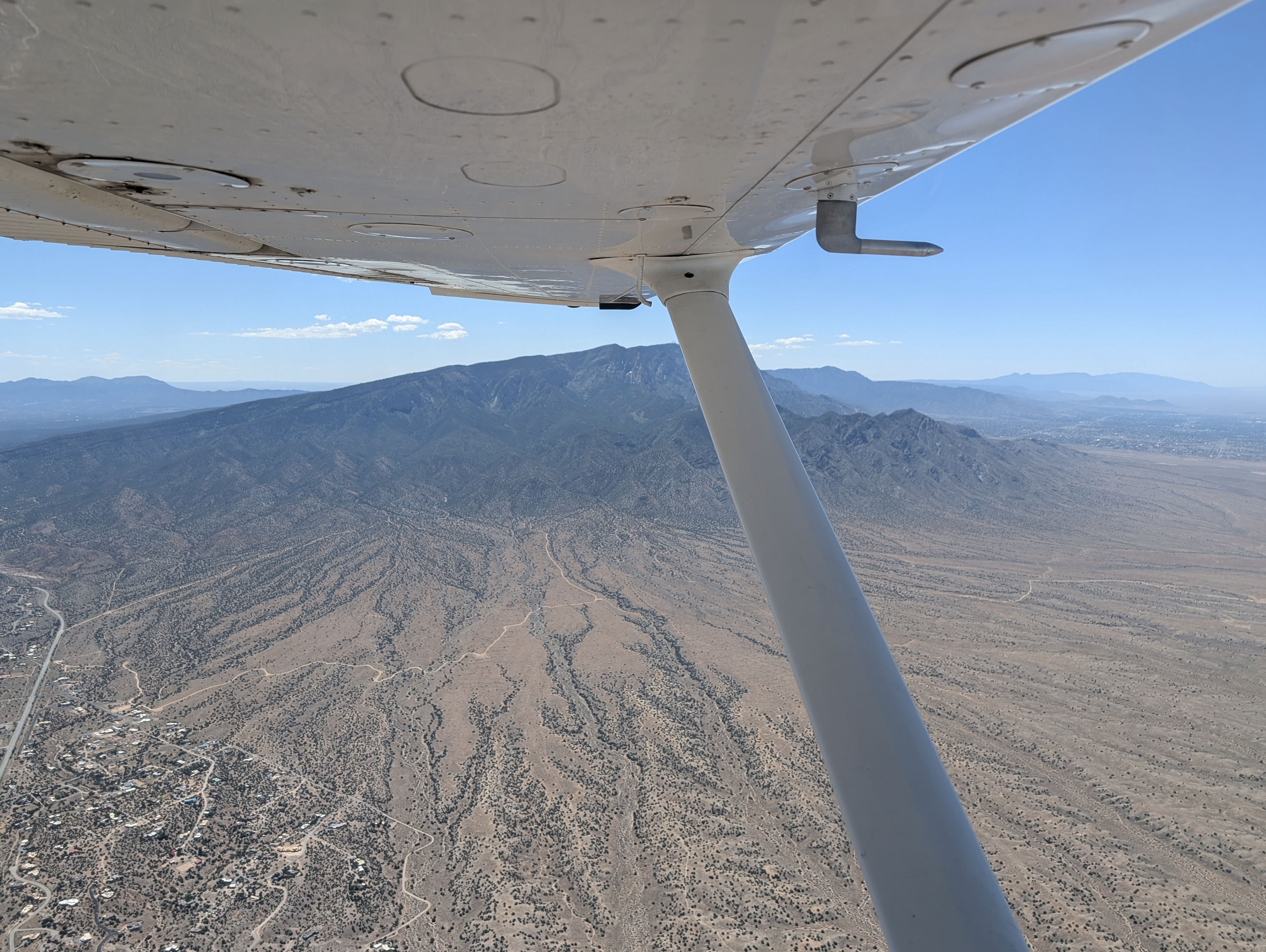
The rest of the flight was fine until reaching KAEG. We cut the corners at bit to follow the low terrain and skirted north of the Sandia Mountains by several miles. Coming into KAEG was only an event because the tower was so … oddly nonchalant. As in, as I approached the threshold I had to ask if I was cleared to land, and after exiting the runway I waited a good 30s before asking if I was approved to switch to ground for taxi instructions. The eventual instructions? “Taxi to parking” … OK.
In Albuquerque, we enjoyed a Colombia restaurant (Ajiaco) that produced some of the best-cooked food we’ve ever eaten, although sullied by the (literally) hour-long wait. Would go again regardless. We also had snow cones (Bahama Bucks’, and mine had a popsicle embedded in it), and loaded hot dogs (Clowndog). The hotel was free with a rewards voucher earned from putting in I’m pretty sure 20+ nights at the Best Western Silicon Valley in the last 12mo. I’m a loyal customer, but it takes a while to earn free rooms when you book bargain-basement.
The weather change the next day would be higher winds – “locally gusty”, I believe it was called. Turns out these words have definitions, by the way – “breezy”, “windy”, “gusty”, etc. are all technical terms. When I woke up at 5:45am the next day to prebrief, the thunderstorms previously forecast for “mid-afternoon” had also been brought forward to 1pm. And there was a new low-level moderate turbulence AIRMET covering about the last 25nm of the flight. Yikes. The flight south, with a slight headwind, had taken us from 7:30am until 11:30am, and that didn’t leave us a ton of margin. The question is how fast the winds would carry us, and whether we’d need a break for gas or stretching.
I was initially worried on departure because ~20 hot air balloons popped up right in our route of flight as we drove to Double Eagle, but by the time we started the engine they were long gone, and I never saw another trace of them. The initial leg east was promising with nearly 30-knot tailwinds that pushed us to 138ks GS. Good sign! Turning north toward KLVS, even turning most of that to crosswinds we still maintained ~128 kts GS all the way to Raton. But the turbulence was continuous now, and although I had no trouble holding altitude, there was a lot more rolling and bumping the whole way.
Luckily the turbulence nearly disappeared after passing Fishers Peak again at 10500, although it did come with a 2-5 knot headwind. Darn shame. Luckily, the tailwinds so far had helped so much that we had no reason to stop for fuel at Pueblo at all, so just like the previous day we amended our destination to something a bit further than KPUB: KBJC, home! According to the G1000 and my back-of-the-napkin math, we’d arrive with ~18g of gas, which would put us above the legal mins (5gal for my current cruise configuration), club minimums (10g), and my personal minimums (15g). I admit I started to feel some fatigue and the altitude here so we dropped it down to 9000 MSL and never strayed above that. I’d have brought it down to 8500 except for the 7800’ mesas strewn around the Palmer Divide. Passing 1000 AGL is close enough for me! The G1000 reported DA at 10700’ and my fingertip pulse oximeter reported 89% at its lowest. There’s an important lesson in there.
Some of the most fun was hanging out on Springs Approach hearing them vector airlines to land. A Southwest Airlines flight passed just 1500ft overhead and a few miles off, and we heard the instructions vectoring them to turn left toward final before they actually made the turn. Very cool to hang out on the same frequencies with those guys. We had requested to transit the charlie but got “no”, and now I know why. They were busy!
The turbulence airmet for the last 25nm was by no means the worst turbulence of the day. Then again, having learned my lesson from a past flight under some fair-weather cumulus over the Palmer Divide months before, I decided to intentionally avoid a particularly large and angry-looking cloud.Maybe that helped.
Getting into KBJC was another affair. Goodness. I’ll leave the ASRS on that topic in my personal files (“asrs-kaeg-kbjc-*.pdf” in Google Drive), but let’s just say that everyone made some mistakes – me, the controller, and two other pilots. Most of us multiple.
Overall, a successful, complex flight. By comparison, the periodic flight down to KOKC to visit Jordan’s folks will be a piece of cake. Nothing but cornfields and convenient places to land. Albuquerque – what an experience! We’ll be back, with a 20kt-faster airplane and a constant-speed prop (DA40 or C182). Thanks for teaching us so much and offering so much excellent gluten-free food.
-
Isn’t that what the USAF “tigers” at initial flight school do there? Love the livery. ↩