Pueblo Memorial
Pueblo is a popular cross-country destination thanks to its restaurant of the flight line and air museum a quick walk away from the tiedowns.
As a side note, I wish the FAA had picked a different label for the mystical “cross-country”. One of the first questions people ask is something like “can you fly us across the country to NYC?” and my answer is “technically yes, financially no”.1 In reality, 14 CFR 61.1(b)(ii)(B) defines “cross-country” as a flight to a point of landing greater than 50 nautical away from the departure airport. So I do need to use the word cross-country, but not its normal meaning. I wish the FAA could’ve called this a “navigational flight” or something more direct!
Anyway, let’s talk some about the flight!
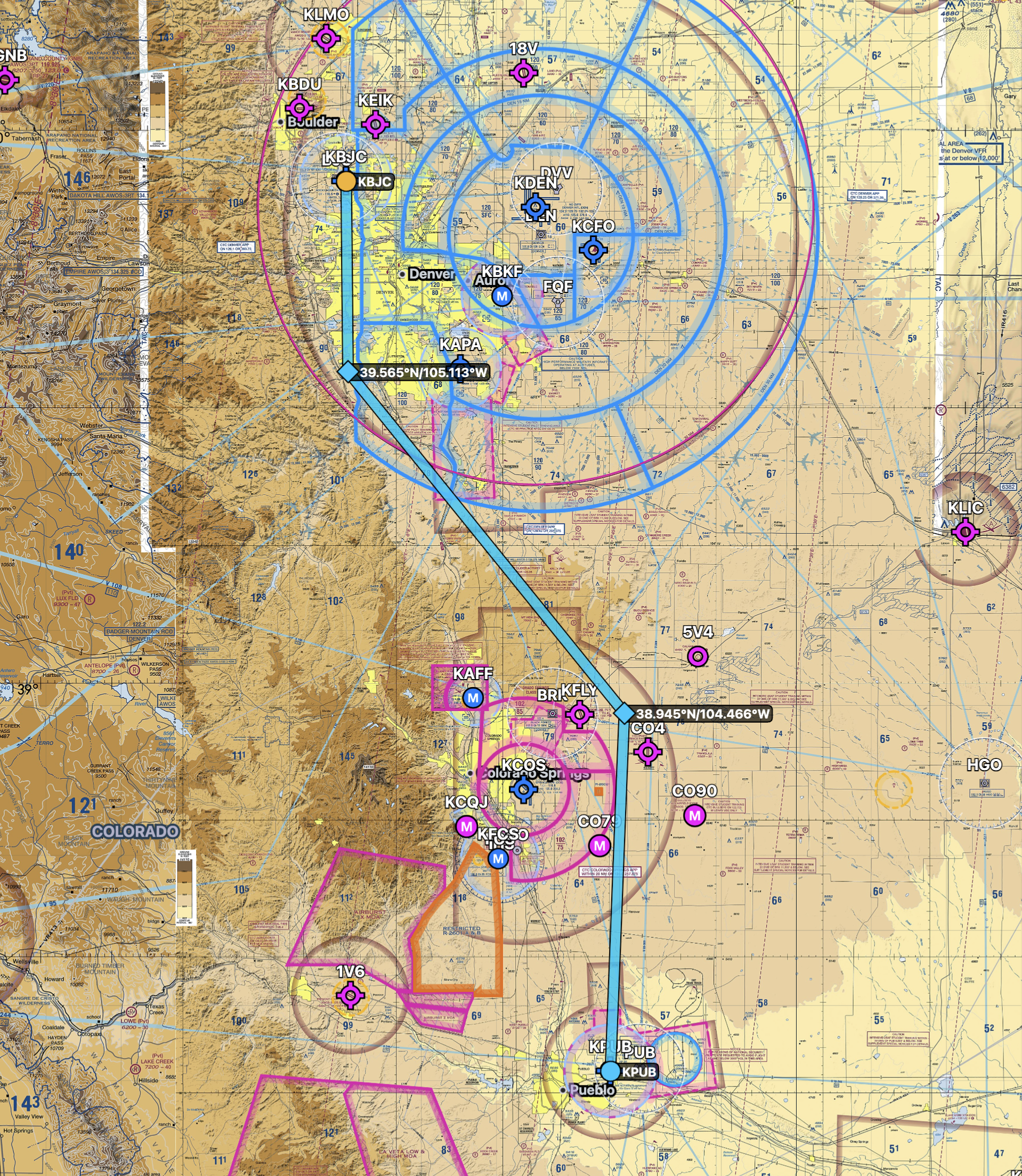
The departure around 9:30am from KBJC (“metro”) was cool – under 60F, even – but busy. I pulled up #3 for departure after my runup and tower was speaking continuously. We requested a south departure from 30R, which would require an extended upwind in order to clear student pilot traffic in the left pattern for 30L. Tower warned us “it’ll be a while”. OK!
In the end, just after takeoff tower requested we stay right traffic and do a downwind departure. They still requested we maintain pattern altitude to avoid conflicting with the limited slot for overflying traffic at 7000. After clearing 30L’s base leg, we were able to turn hard right to proceed on our route to the south, and got a thank-you from tower. All told only one change of plan and 4-ish unusual instructions. Yay!
Side note, at least one place claims KBJC among the top-ten busiest general aviation airports in the country. I don’t know how true that is, but it’s certainly busy! And with heavier traffic than KPAO, and more runways, etc. Great place to learn, since the airport is more complex than KPAO even if the airspace is … well, trivial. Sorry, Denver.
We had a nice flight down the face of the Rockies except for the typical (I’ve encountered it on 2 / 2 flight) aircraft circling the drag strip climbing up to cross the mountains. Had to keep a bit of an eye on him since he was just 500 feet below and climbing at the same rate as I was.
I realized fairly rapidly the plane was not going to enjoy getting up to my planned 11.5k cruising altitude. Indeed, on the return home, with 70F at the surface at ~5k feet, I was only managing 200fpm at 80 knots as I got up to 10.5k. If I were willing to climb longer, I could’ve made it over KCOS’s C, but as it was I decided to just circumvent it2. It was cool to see 95 KIAS in cruise that ended up being so much faster true, and made me feel better in the turbulence. It’s the highest I’ve ever had that plane by a wide margin. I’ve only ever been higher in a C182 crossing the Sierra Nevadas in February with an instructor, and with the westerly winds then we were doing more than 180 knots across the ground!
Anyway, the winds were about as bad as predicted – over 20 knots from the west – but without any turbulence on the trip south that I expected. It was smooth sailing the entire time at 9.5k.
I was able to pick up flight following immediately after leaving the delta on a fairly quiet departure frequency, which was a change of pace from the Bay. There, I pick it up from KPAO Ground and it gets busy in the air. I guess I was far enough away from the north-south arrangement of jets at Denver to find a quiet zone.
I was surprised how little information was transferred between controllers. Twice I was asked after a frequency change to repeat my intended destination. I assumed this was attached to the data block on my aircraft? Perhaps not after all. I don’t remember this happening in the Bay.
Approaching KPUB (“Pueblo”)3 the wind stayed strong until – I kid you not – a mile or two from the airport and several hundred feet AGL. As I approached well into the D I was reading 21 total knots of wind from the west, which worried me as my intended runway was 08R, but their ATIS was reporting winds calm. Hard to believe, right? I was already planning my go-around from flaps 20 and 70 knots approach speed as soon as I encountered the wind shear.
But suddenly when I looked down, I realized the wind had dropped to just 2-3 knots. Insane. Oddly, I didn’t even notice the crosswind drop out, which may say more about my current proficiency than about anything else! I realized only after departure what had happened. On departure, I wasn’t getting nearly the climb performance predicted by the book – more like 200 fpm at 5000 feet and ISA +16C. It was flat west, and I had zero trouble clearing all terrain, but it was certainly odd.
It turned out these effects were likely from the same geography. There is a hill a few hundred feet high a few miles northwest of the airport, putting the airport itself in a bowl. It seems the west wind turns downward to follow the terrain, which kills the horizontal component and creates a downdraft. As soon as I was behind the hill, I lost the crosswinds, but upon departure I discovered the downdraft. Indeed, shortly after I crested 500 AGL and turned north toward Denver, my climb performance went screaming up well to over 500 fpm. Right on the money.
I’ve definitely been taught the effect that hills have on wind, but I wasn’t entirely prepared for the effect a 500-ish foot wide mound that you’d barely call a hill at all could have. This is assuming my diagnosis was even correct!
The flight home was more eventful than the first one. There’s a section of 7500-foot terrain with 500-foot monuments north of KCOS, and there were some cumulus clouds forming above. These were as forecast, so scattered around 12 - 14k. We were well below at 10.5k.
Well, I’ve always read that there’s turbulence associated with cumulus, and I’ve happily flown under and into (during instrument training) clouds there. Denver is a different story. There was absolutely turbulence associated with those clouds. I was under the maneuvering speed (95 KIAS compared to a 100-knot Va) and I had plenty of terrain clearance (2500 above the peaks) and never lost more than ~60 feet of altitude, so we were perfectly safe. But it was definitely not what I’m used to from the Bay! At one point I saw 800 fpm ascent despite pulling power and pushing the nose down. The most annoying part was just manipulating power constantly to avoid overspeeding the prop in updrafts while maintaining altitude in downdrafts.
Once I had a sense of the situation I descended to 8500 feet to see if the altitude was the problem – since our flight at 9500 was uneventful, but our trip north was more exposed at 10500. Nope! That confirmed it was turbulence associated with cumulus formation. I’ll know what to expect next time! And these were just little baby clouds.
On the bright side, the 8500 foot cruising altitude gave us just 500 feet of clearance over the little monuments (legal because it’s a sparsely-populated area and there’s no construction on these monuments). That was a nice view, and much better than the cruise down at 9500 feet. I was surprised what difference just 1000 feet made in terms of enjoying the scenery. It was very beautiful.
Arriving at both KBJC and KPUB I had ATIS at 20nm, advised approach control ~10nm, and they still waited until just about 5 miles to switch me over. I don’t remember what’s typical in the Bay, but it’s something to get used to here.
The arrival at KBJC was no problem at all – it was a very quiet pattern at 2pm or so when we arrived. We did a left base entry to 30L and were off the runway by Bravo. (I hate taxiing on runway 03, even though it’s standard practice at Metro.)
That ended my first XC in the Denver area, my first flight with my fiancée since pre-COVID, just my third solo flight in Denver. It was the first of many cross-countries for a nice lunch, picnic, overnight, scenery, museum, or whatever else in the Colorado / New Mexico / Wyoming / Nebraska / South Dakota area.
If I did this flight again, I’d:
- Leave earlier and return home later. Partly just to have more time sightseeing, but also to have better performance in the morning and evening, and to avoid some of that 2pm turbulence I hit.
- Get my night currency for VFR so I can feel more comfortable planning to return just before sunset.
- Stay high and head west (nearer the mountains) to avoid any cumulus development if possible, since I was able to confirm the clouds, not the mountains, were the source of the turbulence.
That’s all I’ve got!
-
For those wondering, I’d be lucky to conduct that round trip for less than $7000 in my rented C172 from my home airport including hotels! ↩
-
The difference between circumventing it and just going straight over it is on the order of 5 miles, or about 3 minutes of flying. ↩
-
For another annoying flying fact, note that the way you address the airport is NOT always related to the public name, and is NEVER documented in the AF/D. Some are easy, like “Palo Alto Aiport” is called “Palo Alto”, but “Rocky Mountain Metropolitan Airport” is “Metro”. Thankfully “Pueblo Memorial Airport” is “Pueblo” not “Memorial” so I didn’t end up looking like an idiot with my first guess (there was no one else in the pattern to listen to). ↩